The connectivity approach
The work developed in the frame of EU-funded projects ICAROS, ICAROSNET and SMAQ dealt with the development of a novel methodology aiming at providing a comprehensive estimate of tropospheric pollution from particulate matter at different spatial and temporal resolutions at the urban to regional scales needed to provide a spatially-resolved health impact assessment.
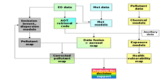
Figure 1. Conceptual representation of the advanced satellite data fusion system.
Current state of the art in air quality assessment and management comprises analytical measurements and atmospheric transport modeling. Earth observation from satellites provides additional information through the calculation of synoptic air pollution indicators, such as aerosol optical depth (AOD). The method developed integrates these three information sources through suitable data fusion techniques providing a comprehensive estimate of tropospheric pollution from particulate matter. Information filtering is used to reduce the error of the fusion algorithm and to produce the best possible estimate of tropospheric aerosol loading. Linking the latter with epidemiological data and activity modeling, allows reckoning the geo-referenced health risk form fine and ultra-fine particulate matter.
The key to the success of the data fusion approach developed is the combination of physical and chemical process modeling that allows linking physical (e.g. optical) properties of tropospheric aerosol with the atmospheric physical-chemical processes that determine total mass concentration, size distribution and chemical composition of particulate matter.
Assimilation of these data sources with ancillary data including classification of population vulnerability to the adverse health effects of particulate pollution in the ambient air integrates them into an optimally managed environmental information processing tool, which can be used for integrated air pollution monitoring and air pollution health assessment at the urban and regional scales.
The method permits the estimation of PM concentration from high to moderate spatial resolution ranging from 10 m to 4 km covering a domain as large as 80-100 x 80-100 km2. The model we developed was applied in Athens (Greece), Munich (Germany), Rome (Italy), Budapest (Hungary) and the regions of Western Macedonia (Greece) and Lombardy (Italy) covering a broad spectrum of climatic conditions, pollution patterns and land use types.
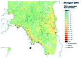
Figure 2. Application of the fusion system in Athens.
The results showed that the conceptual model for tropospheric aerosol formation and fate in the atmosphere that has been developed based on experimental analyses across different European sites allows highly accurate estimates of particulate pollution and their health effects at high to moderate spatial resolution providing a valid approach for overcoming the pitfalls of current atmospheric observation systems and allowing to reduce the overall error to levels lower than the current atmospheric models as well as the pollutant concentration maps produced by spatial interpolation of measurements from the ground.
Its translation into a prototype computational platform is being used in W. Macedonia, Greece, where it has proven its efficacy in accurate estimation of tropospheric aerosol. Its use represents a valid alternative to conventional air quality monitoring, which necessitates the employment of dense and, thus, costly analytical measurement networks reducing significantly the operational cost of air quality management.